Introduction to Class B and C
Class B and Class C are the two most airport-centric airspace classes you’ll encounter as a drone operator. Both exist to protect and manage the flow of manned aircraft around busy airports, like Los Angeles International Airport (Class B) and Nashville Airport (Class C).
B and C differ in size, complexity, and the level of traffic they’re designed to manage.
Class B Airspace
Shape, Surface, and Ceilings
Class B surrounds the nation’s busiest airports, major international hubs handling continuous, high-volume commercial traffic. For drone operators, Class B demands particular attention. The volume and speed of manned traffic moving through these corridors makes unauthorized operation genuinely dangerous.
First we’ll look at the overall shape, and then we’ll break down each of the 3 layers.
Overall Class B Airspace Shape:
Class B airspace is shaped like a 3-layered upside-down wedding cake.
It starts narrow and tight at the ground-floor surface directly over the airport, then expands outward in successive layers as altitude increases.
This upside-down wedding cake design mirrors the actual flight paths of commercial aircraft. Planes descending from cruise altitude need room to maneuver high up and far out. As they get closer to the runway, they’re lower, slower, and more tightly funneled. The airspace is shaped around that reality.

Layer 1 is the innermost cylinder, centered on the airport and beginning at the surface.
It extends up to roughly 4,000–5,000 feet AGL depending on the specific airport.
This is the immediate zone of takeoff and landing activity, the most tightly controlled section of the structure.

Layer 2 sits above and wider than Layer 1, forming the middle tier.
It picks up where Layer 1 tops out and extends to approximately 6,000–8,000 feet AGL, covering aircraft as they transition between the airport environment and higher cruise altitudes.

Layer 3 is the outermost and highest layer, reaching up to 10,000 feet MSL, the universal ceiling for all Class B airspace.
It spans the widest horizontal area, capturing traffic that’s still well out from the airport but within established approach and departure corridors.

Image:
A view of Class B airspace, showing the three-tiered upside-down wedding cake structure centered on a major airport. Each layer extends progressively wider and higher, from the tight inner cylinder at the surface to the broad outermost ring reaching 10,000 feet MSL.

Class C AirspaceShape, Surface, and Ceilings
Class C surrounds airports that see substantial commercial and regional airline traffic, busy, but a step below the major international hubs that anchor Class B. Think mid-sized cities with regular airline service rather than continuous large-scale commercial operations.
The shape is a simpler version of the layered structure you saw in Class B layered upside down wedding cake structure. Where Class B stacks three expanding layers, Class C uses two concentric shelves, each one wider and higher than the one inside it.
- The inner core layer extends from the surface up to 1,200 feet AGL, with a radius of 5 nautical miles. This is the tightest zone, directly over the airport and its immediate surroundings, where approach and departure traffic is most concentrated.
- Above that sits the outer shelf, beginning at 1,200 feet AGL and extending up to 4,000 feet AGL, with a radius of 10 nautical miles. This wider ring captures aircraft as they climb away from or descend toward the airport from a greater distance.
For drone operators, the inner core is your primary concern. Most Part 107 operations take place well below 400 feet AGL, putting you inside Class C airspace if you’re operating anywhere near one of these airports.
Image:
A view of Class C airspace, showing its two-tiered structure centered on an airport. The inner core rises from the surface to 1,200 feet AGL within a 5 nautical mile radius, while the outer shelf extends from 1,200 to 4,000 feet AGL out to 10 nautical miles, creating the characteristic upside-down two-tier layer cake shape.

Class B and C Indications on
Sectional Charts
Class C: Marked by Solid Magenta Lines
Class B: Marked by Solid Blue Lines
Class C on Sectional Charts: Solid Magenta Line
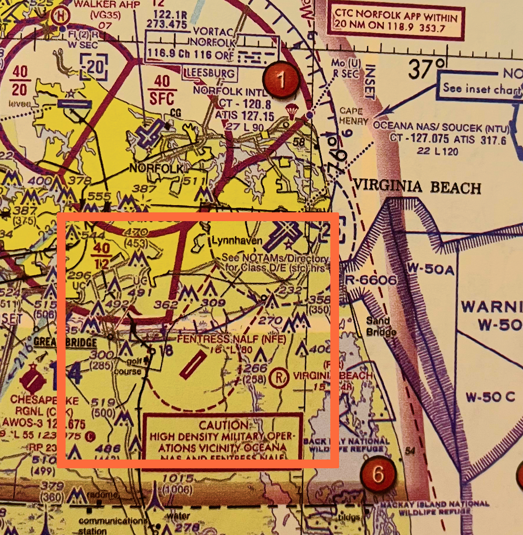
Class C airspace is depicted on sectional charts with a solid magenta line. It typically has a cylindrical shape around the airport, but the exact boundaries are tailored to the airport’s operational needs.
In the image below, Norfolk International Airport is identified as Class C airspace, marked by the solid magenta lines that encircle it.

Class B on Sectional Charts: Solid Blue Line
Class B airspace is depicted on sectional charts with a solid blue line. It typically has a cylindrical shape around the airport, but the exact boundaries are tailored to the airport’s operational needs.
In the image below, Dallas/Ft Worth International Airport (DFW) is identified as Class B airspace, marked by the solid blue lines that encircle it.