Airspace Surfaces and Ceilings
Lesson Focus
This section focuses on the vertical boundaries of Class G, E, and D airspace — specifically where each class begins (its surface) and where it ends (its ceiling).
- Surface — This is the the bottom of an airspace layer. Sometimes the surface begins on the ground itself, and other times a surface can start at higher altitude in the sky.
- Ceiling — This is the the top of an airspace layer, where it transitions into the next class above.
Understanding these boundaries tells you:
- Exactly where one class of airspace ends and another begins
- Whether you need authorization before flying there.
Painting a Picture of Airspace Classes
Each airspace class has two defining measurements: its surface — the altitude at which that layer begins — and its ceiling — the altitude at which that layer ends and the next class begins.
These numbers are not estimates. They are legally binding.
Flying into a class of airspace without understanding its boundaries, or without the required authorization, is a regulatory violation.
As a Part 107 remote pilot, your operations take place in the lowest portion of this system, typically below 400 feet AGL. That puts you squarely in the airspace where Classes G, E, and D intersect.
Depending on where you launch, you could be in uncontrolled airspace with no authorization required, or you could be in controlled airspace where flying without prior approval is illegal.
The difference between those two scenarios often comes down to a few hundred feet of altitude, or a few miles of distance from an airport.
That’s why you need to know exactly where each class begins and ends before you ever leave the ground.
Ceilings and Surfaces of Airspace
G, E, and D
Class G
Class G is uncontrolled and always starts at the surface. It is the ground-level airspace.
Class G is the lowest layer in the system, and it is the only class of airspace that is completely uncontrolled.
It begins at the surface (ground level, zero feet AGL ) and it exists everywhere that controlled airspace has not been established above it.
Uncontrolled means:
- No Air Traffic Control authority governs this airspace.
- No tower
- No requirement to check in before you fly.
As a Part 107 pilot, Class G is where you have the most operational freedom.
–
Where Class G and E Connect:
- Class G doesn’t go up forever. At some point above you, it ends and become Class E.
Depending on where you are, it can end relatively low in the sky at just 700 ft AGL, or it can extend higher before controlled airspace takes over at 1,200 ft AGL.
Above the Class G ceiling, Class E begins, and it occupies the vast majority of the low-altitude sky across the country. The specific altitudes are shown in the chart below.
The diagram below shows how Class G airspace rises from the ground and ends at a ceiling that varies depending on where you are. Above that ceiling, Class E begins.

The diagram above shows Class G airspace rising from the surface ( ground level ) to a ceiling that varies depending on where you are. Near airports and populated areas, that ceiling is lower (700 ft AGL). In remote and rural areas, it extends considerably higher (1,200 ft AGL) before controlled airspace begins. Above that ceiling in both cases, Class E takes over. The white arrows on each side show the difference in height between the two scenarios.
Class E
Class E is the airspace that sits directly above Class G.
In most of the country, it Class E occupies the vast majority of the low-altitude sky, meaning everything from where Class G ends, all the way up to 18,000 feet MSL, where Class A begins.
If Class G is the ground floor, Class E is every floor above it for most of the building.
What makes Class E different from Class G is control.
- Class E is controlled airspace, which means air traffic management is active there.
As a drone pilot, that matters because you are now sharing the sky with traffic that is being actively routed and managed.
Class E’s Surface Types
Class E gets more complex than Class G: unlike Class G, which always starts at the ground, Class E can begin at different altitudes depending on the location.
Class E’s floor — which is the same as Class G’s ceiling — is one of three altitudes:
- Surface (0 ft AGL) — In some locations near airports, Class E begins right at the ground. Class G doesn’t exist there at all. You are in controlled airspace the moment you launch.
- 700 feet AGL — This is the most common floor around regional and municipal airports. Class G occupies the airspace from the ground up to 700 feet, and Class E takes over above that. 700 feet AGL is a number worth memorizing , you will see it constantly on sectional charts.
- 1,200 feet AGL — In remote and rural areas, far from airports and busy traffic corridors, Class G extends all the way up to 1,200 feet before Class E begins. For drone operations in those areas, 1,200 feet is the ceiling of your uncontrolled airspace, though as a Part 107 pilot, your operational ceiling of 400 feet AGL means you’ll remain well inside Class G regardless.
Those three numbers — surface, 700 feet, and 1,200 feet — are the three possible floors of Class E, and the three possible ceilings of Class G. They are the same boundary, just described from opposite directions. The chart below shows where each applies.

The diagram above shows the three possible floors of Class E airspace.
- In the first scenario, Class E begins right at the surface — there is no Class G beneath it.
- In the second, Class G occupies the air from the ground up to 700 feet AGL, and Class E takes over above that.
- In the third, Class G extends all the way to 1,200 feet AGL before Class E begins.
The dashed green line marks the boundary between them; the ceiling of Class G and the floor of Class E are always the same line, just viewed from opposite directions.
Class D
Always starts at ground-level, and has a ceiling of 2,500 feet AGL.

Class D airspace looks like a defined column of airspace that rises from the surface and extends upward to a ceiling of 2,500 feet AGL. At that point it transitions to Class E above.
Unlike Class E, which covers vast regions of the country and can begin at different altitudes depending on where you are, Class D is local. It is built around a particular airport, and sized to manage the traffic pattern around that facility.
Surface and Ceiling of Class D:
- It always starts at the surface (ground level, zero feet AGL).
- The ceiling is always at 2,500 feet AGL.
- Above that, Class D ends and Class E begins.
–
One important caveat: Class D airspace is only active when the control tower is open.
When the tower closes, whether overnight, on weekends, or during holidays, the airspace transitions to Class E or Class G, depending on what exists there without the tower.
The hours of operation for any given Class D airport are published in the Chart Supplement, and they can also be found on the sectional chart itself. Before flying near a towered airport, always verify whether the tower is actually staffed at the time of your flight.

The diagram above shows Class D airspace as a defined column rising from the surface to a ceiling of 2,500 feet AGL, built directly around a towered airport. Class E occupies everything above that ceiling and extends outward on either side.
Practice Quiz
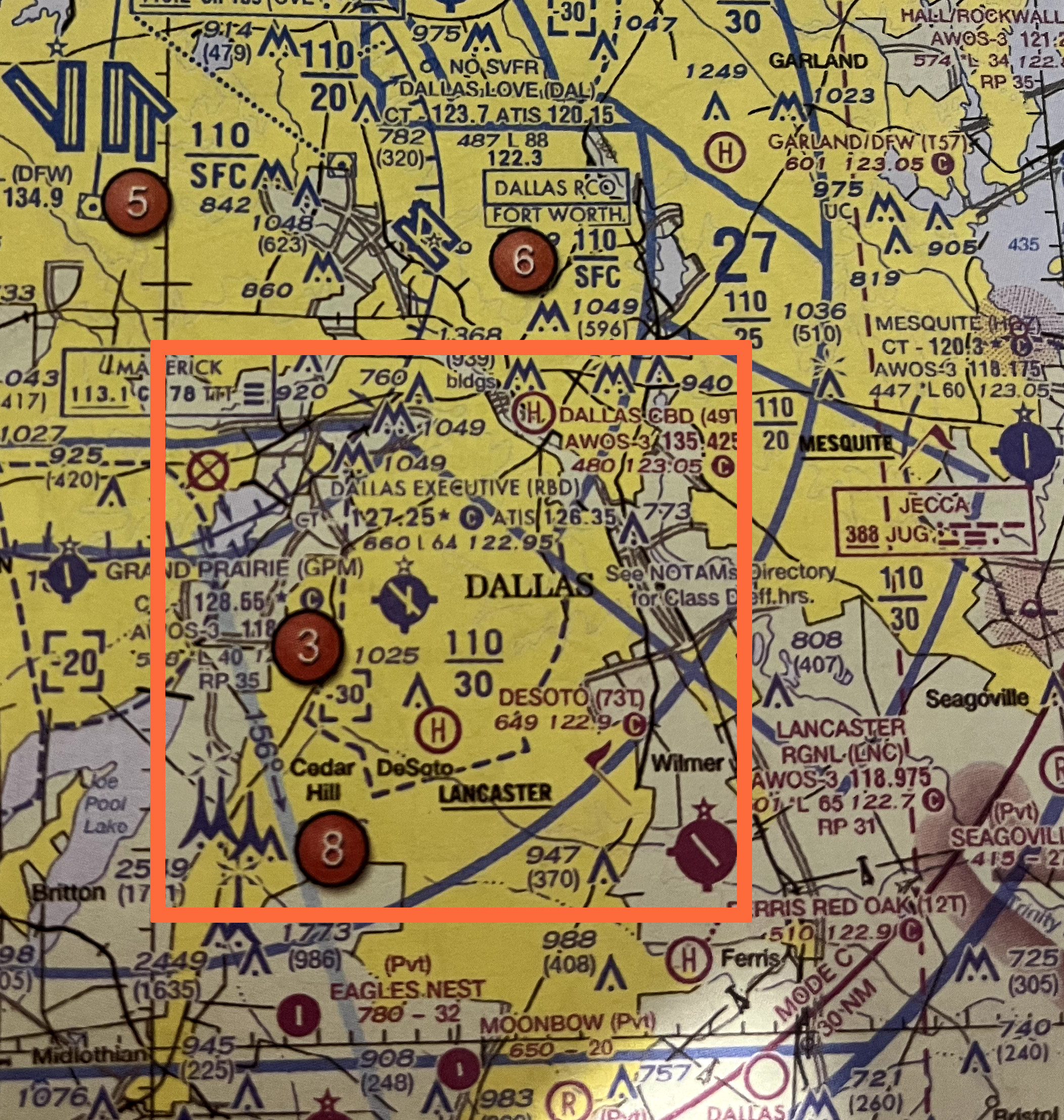
Class D on Sectional Charts
Class D airspace is depicted on sectional charts with a blue dashed line. It typically has a cylindrical shape around the airport, but the exact boundaries are tailored to the airport’s operational needs.

Class E on Sectional Charts
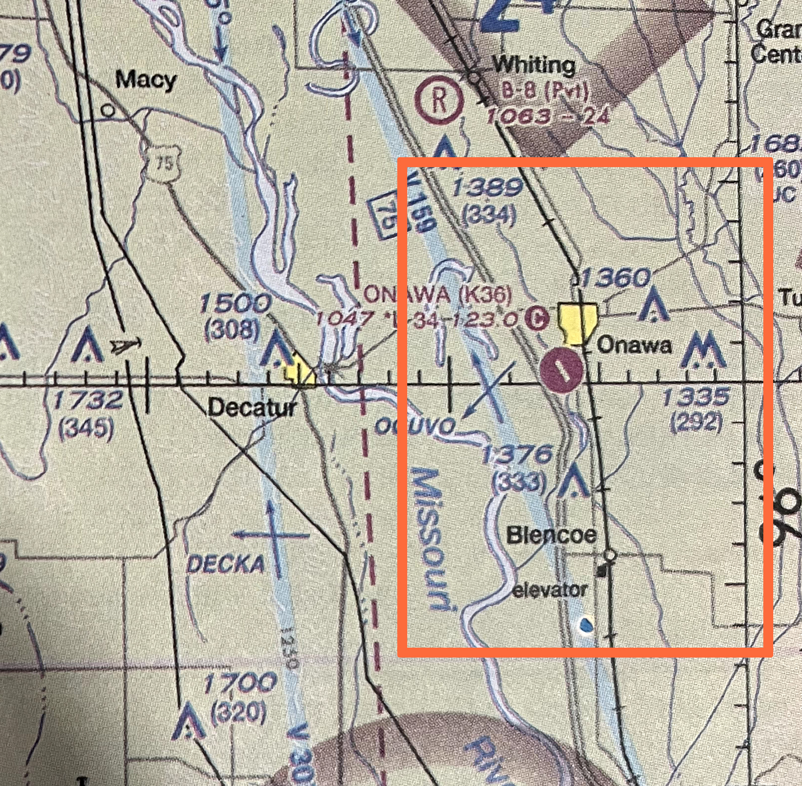
Below is Jamestown Regional Airport (JMS) is situated within two types of Class E airspace.
The area closest to the airport is marked by a dashed magenta line, indicating that Class E airspace starts at the surface and extends up to 700 feet AGL.
Farther out, the shaded magenta line marks where Class E airspace begins at 700 feet AGL.
CHANGE GIF ORDER SO THAT IT’S 1: PLAIN SECTIONAL CHART 2. STARTING AT SURFACE THEN 3. STARTING AT 700 AGL


Practice Quiz
