Career Center

Expand Your Work with Aerial Tech

The Sparrow Archive is citizens-science initiative to provide localized documentation of both gradual and sudden ecological changes.

  • Document Gradual and Sudden Ecological Change In Your Area

  • All Documentation will be Open Source for Current & Future Studies

  • Contributions Include Ground Level Footage & Aerial Drone Footage

Click on each career pathway to learn about the industry, job market, and where drone tech comes in

Conservation

Forest Management

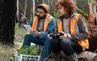
Drones provide aerial surveys for forest management, helping to assess tree health, detect illegal logging, and plan reforestation efforts.

Environmental Research

Researchers use drones to collect data on climate, ecosystems, and atmospheric conditions.

Wind Turbine Inspection

Drone pilots conduct close-up visual inspections to assess the condition of turbine blades and components.

Habitat & Wetland Restoration

Drones support habitat restoration by monitoring the progress of restoration projects and evaluating vegetation growth.

Marine and Coastal Conservation

Drones are used to survey marine ecosystems, monitor coral reefs, and track illegal fishing activities.

Communities

Urban Planning

Urban planning, utilizing drones for data collection, aims to create vibrant communities that prioritize well-being, sustainability, and cultural diversity through sustainable transportation, green spaces, and cultural hubs.

Historical Preservation

Utilizing drones for meticulous documentation, historical preservation aims to protect cultural heritage, celebrate architectural legacy, and sustainably conserve significant landmarks for future generations.

Water Quality Monitoring

Water monitoring initiatives, incorporating drones for early contaminant detection, are essential for safeguarding ecosystems, public health, and ensuring clean water access.

Pollution Control

As communities expand near industrial areas, utilizing drones for pollution monitoring becomes crucial for residents’ well-being.

Structural Integrity

As cities expand, the demand for advanced structural analysis rises, with drones playing a key role. This is particularly crucial for bridges, high-rises, and transportation networks.

Community Green Spaces

As urbanization continues, the need to monitor community green spaces and plan projects like community gardens, local parks, and sustainable urban forests becomes essential. This involves assessing recreational spaces, enhancing biodiversity, and strategically developing green areas that contribute to the health and resilience of the community.

Construction Management

As urbanization continues, the need to monitor community green spaces and plan projects like community gardens, local parks, and sustainable urban forests becomes essential. This involves assessing recreational spaces, enhancing biodiversity, and strategically developing green areas that contribute to the health and resilience of the community.

Real Estate Photography

As urbanization continues, the need to monitor community green spaces and plan projects like community gardens, local parks, and sustainable urban forests becomes essential. This involves assessing recreational spaces, enhancing biodiversity, and strategically developing green areas that contribute to the health and resilience of the community.

Community Event Drone Footage

As urbanization continues, the need to monitor community green spaces and plan projects like community gardens, local parks, and sustainable urban forests becomes essential. This involves assessing recreational spaces, enhancing biodiversity, and strategically developing green areas that contribute to the health and resilience of the community.

Agriculture

Drone technology roles play a crucial practical role in environmental conservation, providing essential aerial support to safeguard Earth’s ecosystems and biodiversity.

Crop Health Monitoring

Drone pilots can offer services to monitor crop health by capturing multispectral or thermal images, enabling farmers to identify issues like disease, pest infestations, or nutrient deficiencies early on.

Livestock Monitoring

Drones equipped with thermal cameras can be used to monitor livestock, ensuring the health and safety of animals on farms and in remote grazing areas.

Pest and Disease Control

Drones are employed for targeted pest control by dispersing beneficial insects or applying pesticides with precision, reducing chemical usage and environmental impact.

Harvest Planning

Insurance companies use drones to assess and document crop damage caused by weather events, enabling prompt and accurate claim processing.

Precision Farming

Drone pilots can support precision agriculture by creating prescription maps that guide variable-rate application of fertilizers, pesticides, and water, optimizing resource use and yields.

Elevating the athletic experience, drones redefine sports with dynamic perspectives, capturing adrenaline-pumping moments, enhancing training regimes, and creating a fusion of technology and physical prowess across various disciplines.

Coach and Athlete Analysis

Drones provide coaches and athletes with valuable aerial perspectives for performance analysis and training, helping them identify strengths and areas for improvement.

Aerial Sports Coverage

Drone pilots capture dynamic aerial footage of sporting events, enhancing sports coverage for television broadcasts, streaming platforms, and promotional content.

Sports Facility Marketing

Drone pilots create compelling promotional videos and photos for sports facilities, showcasing venues, stadiums, and golf courses to attract events and visitors.

Extreme Sports Filming

Drones capture breathtaking footage of extreme sports, such as snowboarding, surfing, and mountain biking, offering a unique perspective for athletes and sponsors.

Sports Photography

Aerial photographers use drones to capture sports events, races, and competitions, providing unique images for athletes, sponsors, and media outlets.

Sports Tourism Promotion

Drones contribute to sports tourism campaigns by capturing the natural beauty and attractions of outdoor sports destinations, encouraging travelers to visit and participate in activities.

Your Opportunities

Aerial Tech Supporting
Agriculture & Precision Farming

Precision Farming

Transforming artistic expressions, drones bring a dynamic and immersive dimension to public art, photography, film, dance, architecture, and cultural preservation, pushing the boundaries of creativity and storytelling.

Revolutionizing Farming

Transforming Agriculture with Precision Farming Drones

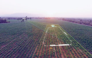
Drones are changing how farmers approach their crops. With a bird’s-eye view, they can monitor fields more efficiently than ever before, making farming smarter and more sustainable.

Detailed Insights & Data

See What’s Hidden From the Ground

Advanced sensors and imaging technologies enable drones to spot issues like nutrient deficiencies, pests, and water stress. This precision reduces waste and boosts crop health, providing real-time insights where it matters most.

Maximize Efficiency

Targeted Actions, Optimized Results

Instead of blanket treatments, drones identify exact areas that need attention, helping to reduce pesticide use, optimize irrigation, and ultimately increase yield while lowering costs.

Mapping & Planning

Data-Driven Decisions for Smarter Farming

Multispectral cameras and GPS technology allow drones to create detailed maps of fields, showing variations in soil quality and crop performance. With this data, farmers can refine planting, irrigation, and harvest strategies for maximum efficiency.

Aerial Tech Supporting

Visual Artists

Whether you’re capturing footage from the ground or from the skies with a drone, your contributions will help build a comprehensive dataset that will enhance our understanding of environmental shifts.

Muralists

Transforming artistic expressions, drones bring a dynamic and immersive dimension to public art, photography, film, dance, architecture, and cultural preservation, pushing the boundaries of creativity and storytelling.

Public Art Documentation

Drone pilots document large-scale public art installations and street art. Getting your Part 107 lets you do this beyond just a mere hobby, but rather as a professional creative.

Your Content Goes Here

Show off your mural process from angles people don’t usually get to see. With drone footage, you can create incredible time-lapse videos for social media or YouTube that highlight the scale, flow, and artistry of your work in a way ground-level cameras just can’t.

Whether it’s your mural or a client’s, aerial shots bring a whole new perspective to the process and the finished piece. It’s the kind of content that stops people mid-scroll, pulls them into your story, and makes your art unforgettable.

What if drones could create murals, turning your digital designs into massive, real-world art pieces? By developing drone-mounted spray paint tools, you’d unlock a whole new way to make art, combining technology with creativity.

With the right software, you could map out a drone’s flight path and program it to spray with incredible precision. By inventing a mechanism to control paint pressure—triggering a spray can exactly when and where needed—you could design an aerial mural using nothing more than your digital design skills.

This innovation could be a game-changer for those who excel in digital art but don’t feel as comfortable with traditional painting techniques. It’s a way to bring digital creations to life on walls, buildings, or any surface you can imagine. This isn’t just about making murals—it’s about redefining what’s possible in art.

Music Videos

Drone technology is transforming the way cinematographers and music video creators tell stories. Imagine capturing breathtaking aerial shots that add depth, scale, and emotion to your work—things that traditional cameras just can’t achieve. Whether it’s sweeping landscapes, dramatic flyovers, or dynamic tracking shots, drones give you the tools to elevate your craft.

But it doesn’t stop there. With drones, you can experiment with new angles and perspectives, creating visuals that feel immersive and unexpected. Combine this with your creative vision, and you can craft music videos or cinematic sequences that leave audiences awestruck.

The future gets even more exciting when you think about choreographing drone movements with the same precision as your camera rigs. Program drones to follow intricate flight paths that sync perfectly with the beat of a song or the flow of a scene. Add effects like lighting or projections to turn a simple shot into an unforgettable moment.

For cinematographers and music video directors, drones aren’t just tools—they’re a creative extension of your vision, opening up endless possibilities for storytelling in ways that feel futuristic and uniquely yours.

Cinemaphotography & Videograph

Drones are employed to monitor water bodies for water quality assessment, early detection of contaminants, and protection of water resources.

VR & AR Aerial Content

Drones are used in the creation of immersive VR and AR experiences, providing aerial content that enhances virtual environments and simulations.

Fashion Photography

Drones capture unique and eye-catching shots for fashion photography, providing a fresh perspective on clothing and models.

Music Videos

Drones provide exciting visuals for music videos, offering sweeping shots and creative angles that enhance the music video’s impact.

Outdoor / Travel Industry Photographer

Drones are used in the creation of immersive VR and AR experiences, providing aerial content that enhances virtual environments and simulations.

Photojournalism Videography & Photography

Drones capture unique and eye-catching shots for fashion photography, providing a fresh perspective on clothing and models.

Architecture and Design

Drones help architects and designers create architectural visualizations and 3D models for presentations and project development.